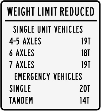
Bridge weight limit sign
Related information
Washington law, RCW 46.44.080, RCW 46.61.450, and RCW 47.48.010, gives counties and cities authority to restrict loads on bridges based on load rating evaluations and other engineering studies.
The majority of Clark County's bridges are more than 50 years old and were not designed or built to meet the current demands on the transportation system.
Load restrictions slow the deterioration of bridges, protect the public's investment in transportation infrastructure and provide safe travel across bridges.
Load restrictions consider a truck's weight, in tons, and how that weight is distributed over its axles. In addition, restrictions also can be placed for the height of trucks. Generally, load restrictions do not impact typical passenger vehicles from traveling on restricted bridges.
Clark County Public Works coordinates with fire districts in the county so they are aware of load-restricted bridges.
Information about height and load restricted bridges:
- Height Restricted Bridges (PDF)
- Load Restriction Bridges (PDF)
- Presentation for May 6, 2025 council meeting (PDF)
The following are the load restricted bridges and alternate routes:
- Whipple Creek Bridge (Bridge No. 11), built in 1963 on NW 179th Street over Whipple Creek.
- Restrictions and map showing alternate route (PDF)
This PDF also shows restrictions and alternate routes for Knapps Station Bridge.
- Restrictions and map showing alternate route (PDF)
- Knapps Station Bridge (No. 12), built in 1962 on NW Krieger Road over Knapps Station.
- Restrictions and map showing alternate route (PDF)
This PDF also shows restrictions and alternate routes for Whipple Creek Bridge.
- Restrictions and map showing alternate route (PDF)
- Knowles Bridge (No. 32) built in 1963 on NE Salmon Creek Avenue over Mill Creek.
- Restrictions and a map showing the alternative route will be uploaded when available.
- Pleasant Valley Bridge (No. 33) built in 1999 on NE 50th Avenue over Salmon Creek.
- Glenwood Bridge (No. 39) built in 1936 on NE 139th over Curtain Creek
- Restrictions and a map showing the alternative route will be uploaded when available.
- Carson Bridge (No. 63) built in 1957 on NE 67th Avenue over Mill Creek.
- Arch Mckee Bridge (No. 127) built in 1934 on NE Gerber-Mckee Road over Chelatchie Creek.
- Restrictions and a map showing the alternative route will be uploaded when available.
- Matney South Bridge (No. 169) built in 1930 on NE 232nd Avenue over Matney Creek.
- Brush Prairie Bridge (No. 201) built in 1960 on NE 156th Street over Salmon Creek.
- Boulder Creek Bridge (No. 203) built in 1960 on NE Boulder Creek Road over Boulder Creek.
- Restrictions and a map showing the alternative route will be uploaded when available.
- JC Ward Bridge (No. 212) built in 1960 on NE 182nd Avenue over Salmon Creek.
- Restrictions and map showing alternate route (PDF)
This PDF also shows restrictions and alternate routes for Venersborg Bridge, Morgan Bridge and for the unnamed bridge on Northeast 167th Street that spans Mudd Creek.
- Restrictions and map showing alternate route (PDF)
- 172nd Avenue Bridge (No. 229), built in 2009 on NE 172nd Avenue over China Ditch.
- 119th China Bridge (No. 261) built in 1935 on NE 119th Street over China Ditch.
- Restrictions and a map showing the alternative route will be uploaded when available.
- 202nd Shanghai Bridge (No. 272) built in 1961 on NE 202nd Avenue over Shanghai Creek.
- Shanghai Creek Bridge (No. 274) built in 1955 on NE 212th Avenue over Shanghai Creek.
- Van Atta Bridge (No. 275) built in 1960 on NE 112th Avenue over Salmon Creek.
- Bonneville Bridge (No. 308) built in 1955 on NE 222nd Avenue over Shanghai Creek.
- Lalonde Culvert (No. 337) built in 2003 on NE 119th Street over Lalonde Creek.
- Restrictions and a map showing the alternative route will be uploaded when available.
Clark County Public Works will continue evaluating its bridges to ensure they comply with federal requirements. Bridges with load restrictions are prioritized for repair or replacement with the goal of removing load restrictions.
Any additional load restrictions will be posted on this webpage.
