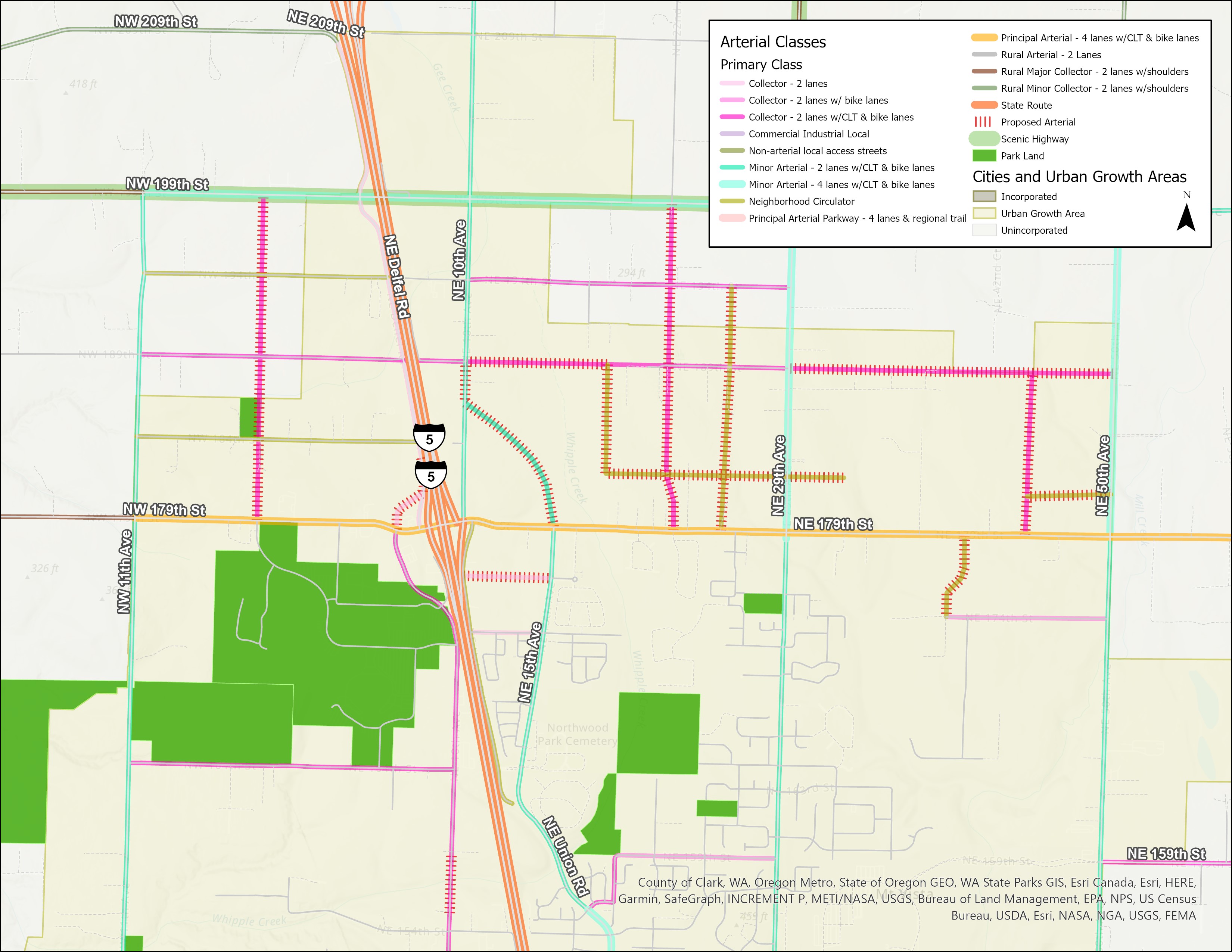
The area around Northeast 179th Street is experiencing rapid development. Development will increase traffic in the area. The existing road network was not designed to accommodate the increased traffic volume. A plan is needed to balance increased traffic volumes with safety and mobility. The goals of the plan are:
- Make main roads safe for drivers, cyclists and pedestrians.
- Prevent traffic congestion.
- Accommodate infrastructure and utility needs of the rapidly developing area.
- Protect the area’s wetlands, creeks and wildlife and reduce stormwater pollution.
Page contents (click to jump to a section)
- About the plan
- Community listening sessions
- Council hearing July 18
- Project timeline
- Public input archive
Learn about this planning effort and various capital projects planned for the area by watching this video:
Additional plan information
Community listening sessions
In late June and early July 2023, Clark County Public Works Director/County Engineer Ken Lader, with Deputy County Manager Amber Emery, hosted several community listening sessions about the 179th Street Access Management and Circulation Plan. The goal of the listening sessions was to provide residents a small-group forum in which to voice their comments and concerns. Additional staff were present to help answer questions.
Slides shown during the listening sessions and meeting minutes are below.
- June 26 listening session meeting minutes
- June 27 listening session meeting minutes
- June 29 listening session meeting minutes
- July 6 listening session meeting minutes
- Listening session slides
- Interactive access management and circulation plan map
At the listening sessions, several residents expressed desire to view detailed project plans and maps. Due to the large size of those files, we are unable to post those on the website. Please contact us and we will work to provide you with copies.
Public hearing July, 18 2023
The Clark County council is holding a hearing about the 179th Street Access Management and Circulation Plan on Tuesday, July 18. The goal of the hearing is to provide council with the Planning Commission’s Feb. 17, 2022 recommendation to approve the 179th Street Access Management and Circulation Plan and provide additional recommended plan changes based on public input. Additional hearing information will be posted and available on June 30, 2023.
County Council meetings will be held in a hybrid format and the public is encouraged to participate in the following ways:
- In person attendance in the Council's Hearing Room, 6th Floor, Public Service Center, 1300 Franklin Street, Vancouver, WA 98666
- Virtually via WebEx (join by phone or computer): information for the meetings will be posted on the Meeting Agendas & Archives page one week prior to the meeting: https://clark.wa.gov/councilors/clark-county-council-meetings
- Watch the meeting live on CVTV (Comcast channel 23)
- Livestream from a personal computer at www.cvtv.org
- Submit written comments via the County website at https://clark.wa.gov/councilors/public-comment or via the US Postal Service to the Clark County Council, c/o Rebecca Messinger, PO Box 5000, Vancouver, WA 98666-5000
- Read your comments into the record. Instructions are available on the County website at https://clark.wa.gov/councilors/clark-county-council-meetings. They can be found at the top of the meeting page, as well as in the related document portion of that meeting entry.
- You may submit items like maps, photos, graphics, articles, legal history, etc., to become part of the record of the county’s decision. To do so, you must provide the item. Hand it to staff at the meeting, attach it to your digital testimony, or physically send it via USPS or a delivery service that will get it to the county before the meeting. Referring to an item, sending a link to an item, or showing an item during testimony without giving it to staff, for example, would not enter an item into the record.
July 18 County Council Hearing
Council work session March 29
The Clark County Council work session on Wednesday, March 29 was about the 179th Street Access Managment and Circulation Plan. The goal of the work session was to provide council with information about the plan. Council is requesting this information as they consider adopting the plan. At the work session, staff presented questions submitted by residents and provide answers, as time allowed.
The council will decide whether to move the plan to a public hearing. If the plan moves to a public hearing, the public will have an opportunity to submit additional comments during the hearing.
The work session will not delve into the circumstances that led to the need for the plan, i.e., development and lifting of the area's urban holding designation.
Click here to learn more about attending the work session.
Work session Powerpoint Presentation
Work Session Outreach
Public input for the work session
Please review these lists of questions submitted by the public, and responses:
Submit questions or comments about the plan that are not reflected in the documents above to 179thstreetproject@clark.wa.gov. Comments received by 5 p.m. Monday, March 20 will be combined with the above documents and, as time allows, be addressed by staff during the work session. Questions submitted after that time will receive responses from staff and be shared with council after the March 29 work session.
Public input archive
- Open House Comments and Responses
- Public Comments (as of 08.11.2022)
- Public Comments (up to July 18, 2023)